Category Archives: Anecdotes

Proposed Extension of Prospect Cemetery

Blacktown & District Environment Group Inc was invited to submit comments on a proposal to reassign land east of the existing St Batholomew’s Church Cemetery, Prospect so that the cemetery could be extended into that area.

The area is shown hereunder:

Prospect - Cemetery Extension

We inspected the land and noted that much of the area was occupied by exotic grasses, herbs and blackberry.

There were, however, some areas of native canopy with native understorey, some areas of native shrubs and, near the Great Western Hwy, a drainage area.

Our submission to Blacktown City Council identified the canopy areas as providing fauna habitat/foraging value as well as providing immediate aesthetic value and, in practical terms, providing shade for attendees of burial services on warm to hot days.

The areas comprising stands of the native shrub Bursaria spinosa were said to provide potential nesting for the Superb Fairy Wren known to inhabit the area. Additionally, the shrubs could provide something of a natural screen to the heavily trafficked Great Western Hwy on the northern side of the area and the M4 Motorway on the southern side. Planting of a native shrub layer (quicker growing) and canopy inside the boundaries of the cemetery area were also recommended for screening purposes but they would also benefit avian fauna.

We also recommended enhancement of the drainage area to make a wetland area which would provide fauna foraging/habitat as well as being an aesthetic water feature of the cemetery.

We await the direction Blacktown City Council takes on this matter but it seems certain the cemetery extension will go ahead.

Cumberland Land Conservancy – Land for Security

Cumberland Land Conservancy is well down the path to taking up ownership of a a 38ha property adjoining Mulgoa Road and Mulgoa Creek, Mulgoa for management in perpetuity for conservation.

An aerial photo of the site they have named “Wallaroo” is provided herewith.

On an afternoon which threatened rain, around 25 members took the opportunity to inspect the site on 20 March 2016 and all remained dryMulgoa Property.

A sub-committee is to be appointed to develop a Plan of Management for the site in consultation with the Nature Conservation Trust.

Link

NO TO FERNHILL SUBDIVISION

IF YOU CARE ABOUT THE FUTURE OF THE MULGOA VALLEY AND OF FERNHILL PLEASE TAKE A FEW MOMENTS TO RESPOND TO THE DEVELOPMENT BEING PROPOSED BY SIMON AND BRENDA TRIPP.

There are two developments being prosed

  1. The first for the ‘Eastern Precinct’ around the historic Mulgoa Public School (this incorporates 50 urban lots with roads, drainage, road lighting, bridges, signage etc.)

  2. And one for the ‘Western Precinct’ which will see subdivision of 11 x 25 acre lots

A BRIEF GUIDE TO WRITING YOUR SUBMISSION

  • Keep it punchy. Use simple language and focus on the big ticket issues.

  • It is OK to criticise elements of the DA. It can be helpful to recommend alternative action.

  • Don’t be overly emotive and challenge the applicant’s claims if you disagree.

  • Refer to relevant legislation, eg Penrith LEP 2010;

  • A short point form submission is acceptable

SUBMISSIONS CAN BE EMAILED to council@penrithcity.nsw.gov.au

SUBMISSIONS CAN BE MAILED to The General Manager

Penrith City Council

PO BOX 60

PENRITH NSW 2750

Remember to request that all Councillors receive a copy of your Submission.

ISSUES WHICH MAY BE IMPORTANT TO YOU FOR THE EASTERN PRECINCT

  1. The proposed subdivision is prohibited in the current E3 zoning.

  2. Use of the heritage incentive clause 5.10 (10) is highly questionable

  3. The northern rural entry to Mulgoa is under threat by this urban development

  4. The subdivision threatens the rural character of Mulgoa village and the vistas of Fernhill

  5. The subdivision impacts on the vistas of other heritage assets eg: Mulgoa Public School, Mulgoa Road

  6. The subdivision impacts on Mulgoa’s rural and historic setting and compromises its aesthetic and cultural values

  7. There is a substantial impact on amenity for residents and visitors to Mulgoa Valley: loss of rural views, altered landscape, traffic, noise, congestion, pollution, lighting signage etc. The worry this has generated is having an impact on the well-being of some residents;

  8. A similar subdivision was opposed by Council in 2010 for reasons of impact on amenity and the fact it was disjointed from Mulgoa village. These reasons today are just as valid;

  9. The subdivision, using the heritage incentive clause, would create a precedent that potentially threatens other heritage assets in NSW including within Mulgoa Valley, ie developers will be able to apply for massive scale developments (such as this one), generating profits far in excess of that which is needed to support PART of the costs associated with maintaining the heritage item. This is NOT the intention of the Heritage Incentive Clause.

  10. The subdivision robs future generations of the rural and environmental values of Mulgoa Valley;

  11. It is a fabrication that Fernhill will fall into disrepair if the subdivision is not approved. The Picnic Races and bio-banking are better alternative uses to conserve Fernhill rather than subdivision;

  12. The subdivision is about Angas Securities recovering bad or doubtful debts and Council should not be part of it

  13. Angas is seeking to extract profits from Fernhill many multiples of what it actually costs to maintain Fernhill. Subdivision is not the best use of the heritage incentive clause to conserve Fernhill

  14. In 2010 Council said it would not expand the Village footprint and, yet, are now considering going against this. Why? It is in contravention of Council’s own ‘Villages Plan’;

  15. Within the Village precinct there will be an increase of population closer to 30%;

  16. Fernhill sits within Mulgoa Valley, Mulgoa Valley does not sit inside Fernhill;

  17. A residents’ survey overwhelmingly opposed subdivision. Council’s first obligation is to listen to the community;

  18. The proposal breaches 100m setbacks from Mulgoa Road and houses will be seen;

  19. Tree planting and post, sandstone entrance and post and rail fencing is not designed to enhance the rural character but hide something which is ugly and out of character with Mulgoa.

  20. The proposal deletes important wildlife corridors;

  21. Urban subdivision will see pollutants (herbicides, insecticides, oils, coolants, detergents) and introduced species: dogs, cats, rats, noxious weeds and exotic plants;

  22. The community does not want Glenmore Park to be transported into Mulgoa.

ISSUES WHICH MAY BE IMPORTANT TO YOU FOR THE WESTERN PRECINCT

  1. Endangered species assessment. The legally required assessments have NOT been lodged for the clearing of vegetation in the Western Precinct. Demand that Council does not issue a conditional approval which would allow the developer to lodge the necessary assessments after a decision had been made and in secret away from public and expert scrutiny.

  2. Proposed ‘offsets’. The developer proposes to trade-off the environmental impacts by protecting (‘BioBanking’) some of the bushland. Elsewhere developers have used these ‘offset’ areas to approve further clearing later on – a trick known a ‘partial retirement’ of the offset. Demand that all credits on the BioBank sites must be retired in full by any development – not left to assist further development.

  3. The Western precinct will have huge impacts on wildlife in the neighbouring Blue Mountains National Park and World Heritage Area. These impacts include nutrient, noise and light pollution which cannot be avoided.

  4. The proposal will completely cut the Greater Southern Sydney Koala Corridor. Koala populations in the Hawkesbury and Campbelltown are linked by a corridor of fertile bushland including the Western Precinct of Fernhill. Koala habitat is not found in the adjoining National Park and the western precinct proposal would break this breeding corridor completely.

  5. Shale Sandstone Transition Forest is the type of vegetation community occurring across the Western precinct (GHD Environmental Consultants 2014). It is about to be ‘uplisted’ from ‘endangered’ to ‘critically endangered’ by the NSW Scientific Committee which means, in the Committee’s own language, that ‘it is likely to become extinct’. This type of vegetation community is home to many endangered animals including Koalas and the beautiful Regent Honeyeater. Most of what remains of this forest is in patches smaller than 10 hectares but Brenda and Simon Tripp propose to destroy 44 hectares.
  6. Bushfire Risk. For those that experienced the bushfires of Christmas Day 2001, you will be aware of the speed at which wildlfire moves. It is the responsibility of Penrith Council in their decision to approve development within the Western Precinct of Fernhill to ensure that the 11 families who purchase within that subdivision can safely evacuate down Fairlight Rd. REMEMBER access to this area is via a ‘one road in, one road out’ scenario and the mass evacuation of all properties west of Mulgoa Rd down Fairlight Rd only may well present fatal consequences for new families. ALSO REMEMBER the highest fire danger days are associated with hot westerly winds which leaves little or no time for families located in the far west of the Cumberland Plain to evacuate – they will be first in line.

You do not have to comment on all the issues, only the ones which are most important to you. There may be other issues which you may wish to add that are not part of the above list.

Bio Map (Draft) for “Green Corridors” Project

The Office of Environment & Heritage (OEH) is proposing to establish “Green Corridors” on the Cumberland Plain and has met with a range of people and entities in the discussion stage.

Conservationists have varying concerns about the project including a sole emphasis on creeklines. Creeklines are not suitable habitat for all fauna species; creeklines are high cost weed maintenance; it will be heavily reliant on biobank funding – that means biobanking land already protected from development as most creeklines are. While some creeklines are only remaining means for connecting key sites – and this is supported – there appear to be too many creeks in the frame for project delivery. See draft map following:

Bio Map Draft

Parklea Correctional Centre Bird Survey

Parklea Correctional Centre in Western Sydney has two wetlands, one very large and one smaller, which have probably been the product of extensive landscaping works on what was perhaps a rural dam and drainage line prior to purchase of the land for a correctional centre by the government two or more decades ago.

The landscaping and the quiet surroundings of the secured outer grounds of Parklea Correctional Centre provide an ideal habitat for a wide variety of birds, particularly water birds.

The following aerial image shows the two wetlands to the west and south-west of the buildings:

Parklea Correctional Centre

The large wetland, by our estimate, occupies 5ha of area and includes quite a sizable island which is well supplied with trees. To the south and north of the wetland are expansive areas of naturally occurring and planted trees. There are shrubs dotting the area to the south but shrubs, particularly Kunzea ambigua, are in more dense supply in the northern area. Native grasses , herbs and groundcovers are in ample supply (along with weed species) but unless protected by shrubs they are subjected to regular slashing. Goodenia, Phyllanthus and Zornia species are well represented.

Management of Parklea Correctional Centre kindly permitted Mark Fuller and Edwin Vella of Cumberland Bird Observers Club as well as Peter Ridgeway and Wayne Olling to conduct a walkaround survey of birds on 12 April 2014.

The day was overcast and rain had fallen prior to the survey. The wetland was full of water and, being at the tail of the season for migratory wading birds, conditions were not best for finding those birds. They were absent.

However, such is the capacity of the wetland to attract a wide range of water birds in the warmer and drier months of the year we anticipate the site would be ‘alive’ with these birds when other wetlands might be struggling.

All things considered, we were not disappointed with the number of birds detected in the two hours of observation. In and around the wetland and in the wooded areas a total of fifty (50) bird species (some introduced) were detected and they can be found here:

Black Swan Cygnus atratus 1
Pacific Black Duck Anas superciliosa
Chestnut Teal Anas castanea 6
Hardhead Aythya australis 12
Australasian Grebe Tachybaptus novaehollandiae 10
Australian White Ibis Threskiornis moluccus
Royal Spoonbill Platalea regia 1
Eastern Cattle Egret Bubulcus coromandus 20
Eastern Great Egret Ardea alba modesta 1
White-faced Heron Egretta novaehollandiae 1
Little Pied Cormorant Microcarbo melanoleucos 1
Little Black Cormorant Phalacrocorax sulcirostris 3
Australasian Darter Anhinga novaehollandiae 1
Brown Goshawk Accipiter fasciatus 1
Australasian Swamphen Porphyrio porphyrio
Dusky Moorhen Gallinula tenebrosa
Eurasian Coot Fulica atra approx. 300
Masked Lapwing Vanellus miles
Rock Dove Columba livia
Spotted Dove Spilopelia chinensis
Crested Pigeon Ocyphaps lophotes
Long-billed Corella Cacatua tenuirostris
Little Corella Cacatua sanguinea
Rainbow Lorikeet Trichoglossus moluccanus
Musk Lorikeet Glossopsitta concinna
Eastern Rosella Platycercus eximius
Red-rumped Parrot Psephotus haematonotus
Superb Fairywren Malurus cyaneus
Yellow-faced Honeyeater Lichenostomus chrysops
White-plumed Honeyeater Lichenostomus penicillatus
Noisy Miner Manorina melanocephala
Red Wattlebird Anthochaera carunculata
Eastern Spinebill Acanthorhynchus tenuirostris
Yellow Thornbill Acanthiza nana
Grey Butcherbird Cracticus torquatus
Black-backed Magpie Gymnorhina tibicen
Pied Currawong Strepera graculina
Black-faced Cuckooshrike Coracina novaehollandiae
Australian Golden Whistler Pachycephala pectoralis
Rufous Whistler Pachycephala rufiventris
Spangled Drongo Dicrurus bracteatus 1
Willie Wagtail Rhipidura leucophrys
Magpie-lark Grallina cyanoleuca
Restless Flycatcher Myiagra inquieta 1
Australian Raven Corvus coronoides
Welcome Swallow Hirundo neoxena
Common Myna Acridotheres tristis
Common Starling Sturnus vulgaris
Red-browed Finch Neochmia temporalis
Double-barred Finch Taeniopygia bichenovii

We are indebted to management of Parklea Correctional Centre for the maintenance of a viable bird habitat in Western Sydney and for affording us the opportunity to observe its function.

For some pics of the wetland and some of the birds sighted subscribe via this website for the Cumberland Conservation Newsletter. Courtesy of Mark Fuller and Edwin Vella the pics appear in the May issue of the Newsletter.

Wayne Olling

Catherine Fields & Marsden Park North Urban Development Precincts

Catherine Fields

The announcement by Premier Barry O’Farrell on Saturday 28 December 2013 about the release of land at Catherine Fields for over 3,000 houses gives cause for discomfort to conservationists. This writer has not walked the site but it is noted Eco Logical did the flora & fauna survey and the aerial image below indicates most of the canopy is along creeklines. Presumably, this is to be retained. As well, a recommendation was made for trees with hollows away from creeklines to be retained. Disturbingly, the site is inhabited by the TSC listed Australian Bittern yet Eco Logical has been weak in not recommending retention of the large rural dam in the centre of the site. OEH recommended retention but is not strong on it. The exhibited site plan proposed removal of the dam for housing. We don’t know as yet whether it has been retained in the final site plan:

Catherine Field Aerial

Marsden Park North Precinct

Is Greater Western Sydney going to be worth living in?  It is the target of get-rich-quick land developers at a pace never before seen. Western Sydney does not have the beaches, the harbour, the sea breeze enjoyed by those in inner Sydney or east and north of Sydney. Greater Western Sydney has only its bush – its flora & fauna – but the modern day ‘development’ mentality is determined to take that from us and leave us with a sea of concrete, bitumen and brick. The development lobby have access to government and they have their way.

Hard on the heels of the Catherine Fields Urban Development announcement is the finalisation of negotiations between land owners and the government for another urban development called Marsden Park North. These follow announcements of development in other places in South-Western Sydney such as Oran Park and Edmondson Park (to name two) and development precincts in Riverstone, Marsden Park Industrial Estate and a 10,000 house estate across the road from Marsden Park North on the former historic ‘Clydesdale’ site. Once rural settings are being obliterated.

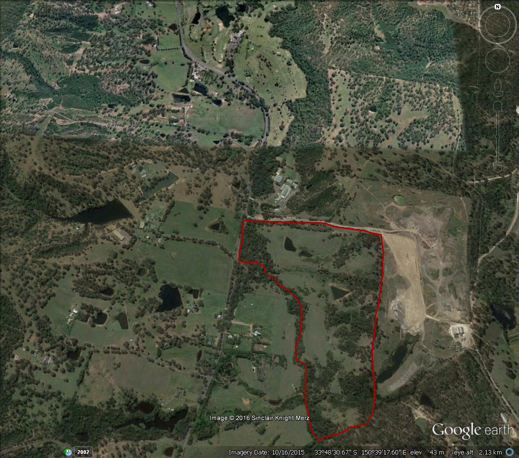
Marsden Park North Precinct is bounded by Richmond Road, South Creek, Eastern Creek and Garfield Road West. That part of the precinct we shall now refer to is bounded by South Creek to the west & north, Richmond Rd to the south, Park Rd to the east and Eastern Creek to the east and north and it is outlined in red on the map below. We don’t know all the conservation and heritage values of the land but we do know some.

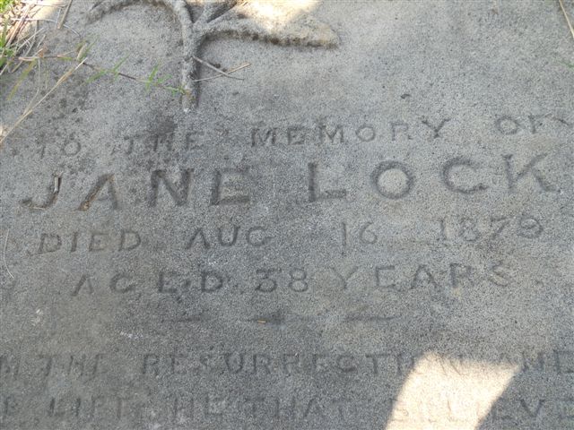
In the 19th Century St Phillip’s Church of England church building was constructed just off Richmond Rd and just short of South Creek. A cemetery was also commissioned and became the burial site for some of the Lock family through whom present day Darug people are descended. Other pioneers such as the Worboys were also buried there. A surprise to the people then and something to be noted by Planners today is that South Creek can flood exceptionally high. The wooden church building was washed away by flood long ago. Only the small cemetery with its headstones (some overgrown with grass) remains today although the Anglican Diocese of Sydney still owns the small area albeit surrounded by the large land holding of development proponent Angliss Estate (Garfied). The site is included in the LEP of the City of Blacktown as an historical site.

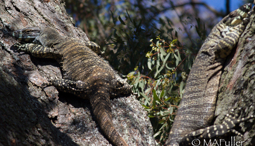
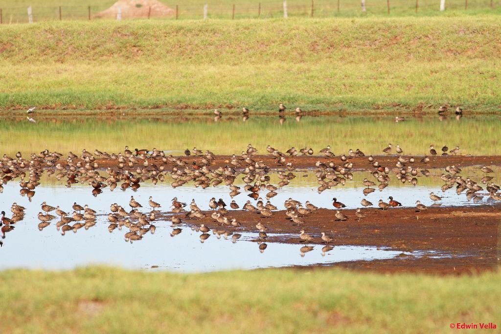
Along the margins of South Creek are some old growth Eucalyptus moluccana and Eucalyptus amplifolia. Also, in the floodplain of South Creek is a wealth of water birds – frequenting, inhabiting, foraging and breeding. On the eastern portion of the site and easily visible from Park Road is bushland containing abundant TSC listed Grevillea juniperina and Pultenaea parviflora. The land is habitat for a mob of at least 40 kangaroos and Lace Monitors have been seen.

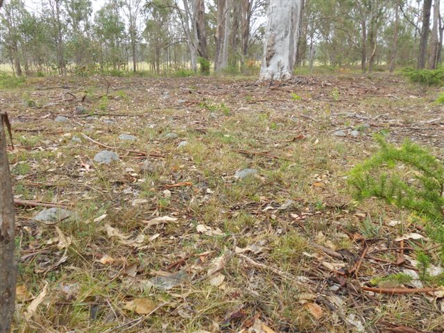
A particular area adjoining and including the Angliss Estate along Park Road is identified in the City of Blacktown’s LEP because of its Aboriginal heritage significance – it is the site of a large number of Silcrete rocks & boulders. Advice from Darug elders indicates the area was a work site of early indigenous people for the making of tools, implements and weapons. A healthy Eucalyptus tereticornis at the base of the site is said to give appearance of dating back at least to the mid 19th Century and, as such, would add interpretation to the foregoing.

Here is a Google Earth image of the Angliss  and MAC 1 estates we speak of:

Marsden Park North Precinct - Aerial

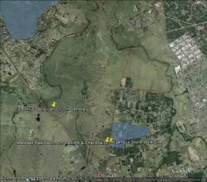
Red outline signifies approximate boundary of the currently considered Angliss Estate and MAC 1 development footprint.

We are left to await the extent of sympathy existing within development proponents and government for the natural and cultural  heritage of Western Sydney and, more specifically, the City of Blacktown.

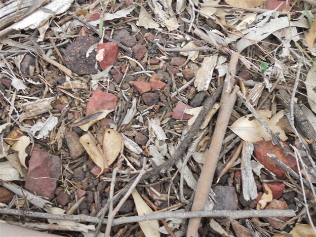
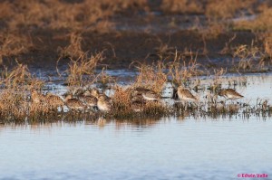
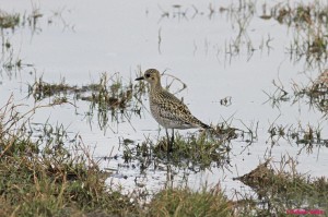
Immediately below are images of water birds observed by others on the site. Near the bottom of the gallery is the headstone of one of the Lock family buried at the site. It is that of Jane Lock, daughter-in-law of Maria Lock, sister to Colebee. Maria Lock is present day Darugs’ link to their early heritage. Other Lock family headstones (not Maria’s) are thought to be covered by grass. The final two photos present as a bushland scene said to contain 50 to 100 Silcrete boulders amid grass and leaf litter and, among the boulders, are what Darug elders say are discarded Silcrete Flakes (chips). The boulders are thought to have been ‘worked’ by early indigenous people for the making of tools, weapons and implements.

MP 1 Australian%20Painted%20Snipe%20-%20Riverstone,%20NSW%20-%20071012%20-%207MP 2 Australian Painted Snipe Riverstone    MP 6 Sharp-tailed Sandpiper Riverstone

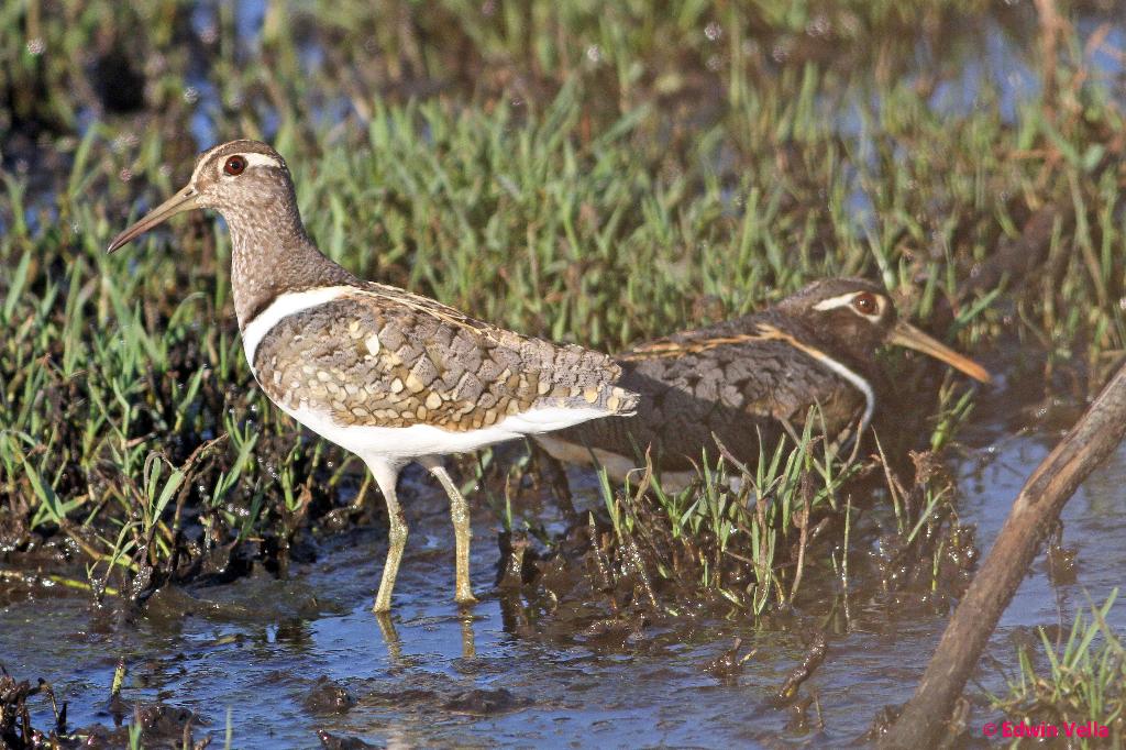
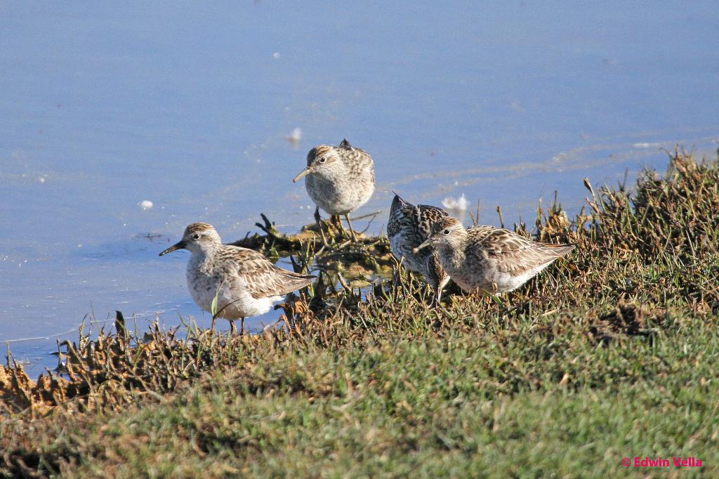
Australian Painted Snipe                                     Sharp-tailed Sandpiper

MP 4 Pacific Golden Plover Riverstone    Australian Painted Snipe Riverstone NSW

Pacific Golden Plover                                            Australian Painted Snipe

MP 3 Black-winged Stilt Riverstone    MP 5 Plumed Whistling-duck Riverstone

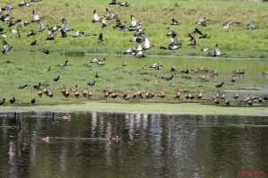
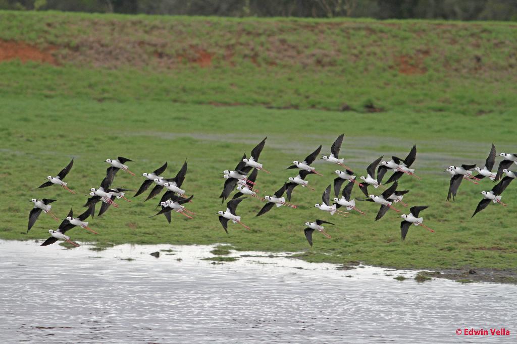
Black-winged Stilt                                                  Plumed Whistling-duck

MP 7 Sharp-tailed Sandpiper Riverstone   MP 8 water birds Riverstone

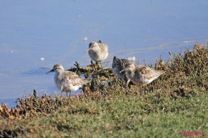
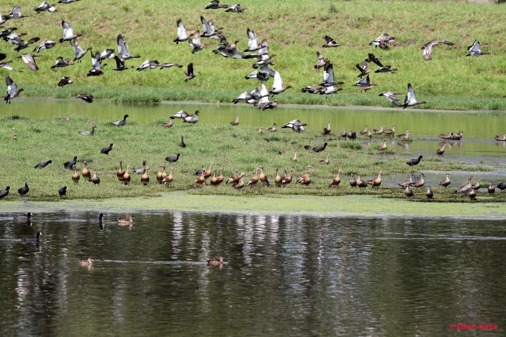
Sharp-tailed Sandpiper                                             Assorted Water Birds

Waterfowl Riverstone NSW   Marsden Park North Precinct - 21 Dec 2013 007

Waterfowl                                                               Gravestone of Jane Lock in Cemetery

Marsden Park - Indigenous Stone Work Site  003    Marsden Park North Precinct - 2 Jan 2014 003

Suggested Indigenous Stone Work Site                Discarded Red Silcrete ‘Flakes’ are abundant